Discover Nags Head
Tucked between Kill Devil Hills and Hatteras Island, Nags Head is an Outer Banks destination known for its endless stretches of pristine shoreline.
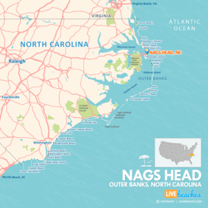
![]() Map of Nags Head, North Carolina
Map of Nags Head, North Carolina
Nags Head offers a little something for everyone without the sensory overload brought on by typical resort beach resorts that feature sparkling boardwalks and flashy hotels.

Nags Head is considered the center of the Outer Banks, offering a wide array of activities in all directions including Jockey’s Ridge State Park, the largest sand dune on the East Coast. Adventures seekers can get their thrills with hang-gliding and other daring sports.
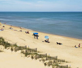
Nags Head is often considered the center or hub of the Outer Banks, offering a wide array of activities in all directions. The area has over 40 public beach access points which makes it a great place for beach-lovers, seeking clean and not over-crowded shores.
One of the most popular attractions in Nags Head is Jockey’s Ridge State Park, which features active sand dunes, the largest on the East Coast. Adventures seekers can get their thrills with hang-gliding and other daring sports.
The unique flora and fauna of the area are explained at a local museum. From historical points and lighthouses to modern shops and restaurants, Nags Head is the quiet, but exciting, getaway families seek.
![]()
Live Webcams
View live webcams from Nags Head, North Carolina. Check the current weather conditions, beach activity, and enjoy spectacular sunsets and sunsets. It’s not quite the same as being here but it’s a great way to daydream from far away!
![]()
Map of Nags Head & Nearby Beaches
Use the map as a guide to find the best beaches in North Carolina and locate nearby cities and points of interest.
• Nags Head, NC Map
• Map of Outer Banks, NC Beaches
• Map of Beaches in North Carolina
![]()
Nags Head, NC Average Temperatures
Wondering the average monthly temperatures in Nags Head, NC? Use this chart below to view the average daily high and low air temperatures including the average ocean temperature per month.
• Average High Temperatures per Month
• Average Low Temperatures per Month
• Average Ocean Temperatures
Planning trip to Nags Head? Visitors are encouraged to pick up a free travel guide from the tourism information center. Local guides include deals on places to stay and things to do. You’ll find budget-friendly discounts and coupons to save money once you get there.


Nags Head, North Carolina Average Temperatures
Use this weather chart as a guide to view the average air and ocean temperatures in Nags Head, NC.
The average air temperature in the summer varies between 85-90 degrees.
The average ocean temperature in the summer varies between 75-80 degrees.
| Average High | Average Low | Average Ocean Temp | |
|---|---|---|---|
| January | 51 | 36 | 45 |
| February | 54 | 38 | 44 |
| March | 60 | 42 | 47 |
| April | 69 | 52 | 58 |
| May | 76 | 58 | 68 |
| June | 84 | 68 | 75 |
| July | 88 | 73 | 78 |
| August | 86 | 72 | 80 |
| September | 81 | 68 | 76 |
| October | 72 | 58 | 67 |
| November | 64 | 49 | 58 |
| December | 56 | 41 | 54 |
Average high, low and ocean temperatures in Nags Head. Sources: Accuweather, Weather.com, NOAA Climate.gov.


