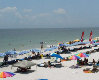
Discover Gulf Shores, AL
A well-liked vacation spot in Alabama, Gulf Shores is well-known for its stunning beaches and outdoor pursuits. Gulf State Park offers visitors the chance to unwind on its sandy beaches, stroll along its picturesque pathways, and go on dolphin cruises to witness these frolicking animals in the wild.
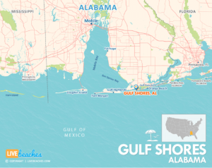
![]() View Map of Gulf Shores, Alabama
View Map of Gulf Shores, Alabama
Families will love the Alabama Gulf Coast Zoo and The Wharf because they provide a variety of activities such as animal experiences, dining, shopping, and entertainment.

Mini-golf, arcade games, and thrilling water rides are available at Adventure Island and Waterville USA for those seeking more daring diversions. History aficionados may tour the ancient Fort Morgan, while nature lovers can hike and view wildlife at Bon Secour National Wildlife Refuge. Inland or deep-sea fishing is a popular activity that provides an insight into the maritime culture of the area.
Gulf Shores is a fantastic beach vacation destination because it provides a balance of adventure, relaxation, and family-friendly activities.
Visitors are encouraged to pick up a free destination guide from the local visitors center or tourism information center. Local guides include accommodations, attractions, water activities, events & festivals, and popular restaurants.
![]()
Live Webcams
View live webcams from Gulf Shores, Alabama. Check the current weather conditions, beach activity, and enjoy spectacular sunsets and sunsets. It’s not quite the same as being here but it’s a great way to daydream from far away!
![]()
Map of Gulf Shores & Nearby Beaches
Use the map as a guide to find the best beaches in Alabama and locate nearby cities and points of interest.
• Gulf Shores, AL Map
• Map of Beaches in Alabama
![]()
Gulf Shores, AL Average Temperatures
Wondering the average monthly temperatures in Gulf Shores, AL? Use this chart below to view the average daily high and low air temperatures including the average ocean temperature per month.
• Average High Temperatures per Month
• Average Low Temperatures per Month
• Average Ocean Temperatures


Gulf Shores, Alabama Average Temperatures
Use this weather chart as a guide to view the average air and ocean temperatures in Gulf Shores, AL.
The average air temperature in the summer varies between 85-90 degrees.
The average ocean temperature in the summer varies between 80-85 degrees.
| Average High | Average Low | Average Ocean Temp | |
|---|---|---|---|
| January | 60 | 38 | 53 |
| February | 64 | 40 | 53 |
| March | 70 | 46 | 61 |
| April | 78 | 53 | 70 |
| May | 83 | 63 | 77 |
| June | 89 | 69 | 82 |
| July | 90 | 72 | 85 |
| August | 89 | 71 | 83 |
| September | 87 | 66 | 81 |
| October | 75 | 50 | 73 |
| November | 71 | 46 | 62 |
| December | 63 | 42 | 57 |
Average high, low and ocean temperatures in Gulf Shores. Sources: Accuweather, Weather.com, NOAA Climate.gov.


