Discover the Outer Banks
If you’re looking for boardwalks, oceanfront hotels, flashy nightlife, or main street tourist traps, you won’t find it here. The natural beauty of the fragile islands and the pristine beaches is what makes the Outer Banks so unique. With miles of sandy beaches and loads of offshore fun, the Outer Banks offers a wide variety of outdoor activities that are well suited for everyone.
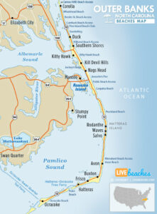
![]() Map of Outer Banks, North Carolina
Map of Outer Banks, North Carolina
The Outer Banks stretches nearly 100 miles long and is surrounded by 900 miles of water. The National Park Service protects more than 70 miles of the coastal region. The barrier island’s mix of rolling sand dunes, beach grasses, and beautiful beaches has been charming visitors and residents for generations.
View live webcams in Outer Banks, check current weather conditions, and see what’s happening at the beach.
Planning trip to Outer Banks? Visitors are encouraged to pick up a free travel guide from the tourism information center. Local guides include deals on places to stay and things to do. You’ll find budget-friendly discounts and coupons to save money once you get there.
Outer Banks, North Carolina Average Temperatures
Use this weather chart as a guide to view the average air and ocean temperatures in Nags Head, NC.
The average air temperature in the summer varies between 85-90 degrees.
The average ocean temperature in the summer varies between 75-80 degrees.
| Average High | Average Low | Average Ocean Temp | |
|---|---|---|---|
| January | 51 | 36 | 48 |
| February | 55 | 38 | 46 |
| March | 61 | 42 | 49 |
| April | 70 | 52 | 59 |
| May | 77 | 58 | 68 |
| June | 84 | 69 | 75 |
| July | 87 | 74 | 78 |
| August | 87 | 72 | 80 |
| September | 82 | 68 | 76 |
| October | 73 | 59 | 69 |
| November | 65 | 49 | 58 |
| December | 56 | 40 | 55 |
Average high, low and ocean temperatures in Outer Banks. Sources: Accuweather, Weather.com, NOAA Climate.gov.


