Discover Annapolis, MD
Annapolis, Maryland’s capital, is located 30 miles southeast of Baltimore, MD. Annapolis is known for its Maryland blue crabs, Chesapeake Bay oysters and City Dock – historic heart of Annapolis, where it connects with the waters of the Chesapeake Bay. Annapolis has a lot to offer in terms of activities, history, and maritime culture.
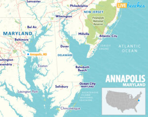
![]() View Map of Annapolis, Maryland
View Map of Annapolis, Maryland
Take a tour of the USNA campus, pay a visit to the Naval Academy Museum, and take in the stunning Chapel. Examine the oldest state capitol that is still being used for legislative purposes, the location where George Washington tendered his resignation.
Take a stroll around the well maintained 18th-century buildings in the historic neighborhood. Take a sailing lesson, hire a boat, go on a boat tour on the Chesapeake Bay, or take pleasure in picturesque sailing tours and cruises to appreciate the views from the sea.
Take the kids on a fun boat cruise called Pirate Adventures on the Chesapeake for family-friendly activities. Enjoy locally produced ice cream while exploring the ancient town and shopping on the main thoroughfares. One of the biggest and longest running in-water boat displays in the nation is the Annapolis Boat Show, one of the many events held in Annapolis. There will be special events and activities all throughout Annapolis to commemorate Maryland’s history. For travelers of all ages, Annapolis provides a fascinating blend of history, culture, outdoor activities, and coastal beauty.
![]()
Live Webcams
View live webcams from Annapolis, Maryland. Check the current weather conditions, and enjoy spectacular sunsets and sunsets.
![]()
Map of Annapolis, MD & Nearby Beaches
Use the map as a guide to find the best beaches in Maryland and locate nearby cities and points of interest.
• Annapolis, MD Map
• Map of Beaches in Maryland
![]()
Annapolis, Maryland Average Temperatures
Wondering the average monthly temperatures in Annapolis, MD? Use this chart below to view the average daily high and low air temperatures including the average ocean temperature per month.
• Average High Temperatures per Month
• Average Low Temperatures per Month


Annapolis, Maryland Average Temperatures
Use this weather chart as a guide to view the average air temperatures in Annapolis, MD.
The average air temperature in the summer varies between 75-80 degrees.
| Average High | Average Low | Average Ocean Temp | |
|---|---|---|---|
| January | 43 | 30 | |
| February | 49 | 32 | |
| March | 56 | 39 | |
| April | 68 | 47 | |
| May | 77 | 56 | |
| June | 85 | 68 | |
| July | 89 | 73 | |
| August | 88 | 70 | |
| September | 81 | 64 | |
| October | 70 | 52 | |
| November | 57 | 42 | |
| December | 47 | 34 |
Average high, low and ocean temperatures in Annapolis. Sources: Accuweather, Weather.com, NOAA Climate.gov.


